Big Sur is one of the most dramatic stretches of coastline in California: 90 miles of redwood canyons, high cliffs, crashing surf, and winding Highway 1 pullouts that make even short drives feel cinematic. It is not a traditional town with a walkable center or neat set of attractions. It is a rugged coastal region, and planning the right pace matters just as much as choosing the right stops.
This guide covers the best things to do in Big Sur, the most worthwhile viewpoints, standout hikes, where to stay, what to know before you go, and how to shape a realistic one-day or two-day itinerary. If you want a trip that feels beautiful but also well-planned, this is where to start.
Why Big Sur Is Worth the Trip
Big Sur earns its reputation because the landscape changes constantly but never loses intensity. One moment you are driving through redwood shade beside the Big Sur River. A few curves later, the road opens to a sheer drop above the Pacific, with the coastline unfurling for miles ahead.
The appeal is not just visual. Big Sur rewards travelers who want a slower, more deliberate kind of trip. There are no big commercial centers, cell service can be spotty, and lodging is limited compared with other California destinations. That relative sparseness is part of what makes it memorable. The coast still feels raw, and the drive still feels like an experience rather than a transfer between stops.
For Central Coast travelers, Big Sur works especially well as:
- a one-day scenic drive from Monterey or Carmel
- a one- or two-night coastal escape
- part of a longer Highway 1 itinerary that continues south toward Cambria, Cayucos, or Morro Bay
- a trip anchored by ocean viewpoints, short hikes, and a few carefully chosen stops rather than a packed schedule
Best Things To Do In Big Sur
Drive Highway 1 Slowly
The drive itself is the main event. If you rush through Big Sur, you will mostly remember guardrails and curves. If you allow time for scenic pullouts, short walks, and pauses between major stops, the region starts to make sense.
Whenever possible, treat the drive as a half-day or full-day experience rather than a quick pass-through. Even if you are not hiking much, Big Sur is best experienced with time built in for weather shifts, traffic delays, photo stops, and the simple reality that some views deserve longer than five minutes.
Stop At Bixby Creek Bridge
Bixby Creek Bridge is one of the most recognized landmarks on Highway 1, and for good reason. The bridge’s arch spans a deep canyon just north of the core Big Sur coastline, and the setting is as striking in person as it is in photographs.
The best approach is simple:
- stop at a safe turnout
- take in the scale of the canyon and coastline
- avoid treating it as a rushed “photo and leave” moment
It is one of the best early stops when driving south from Carmel, and it sets the tone for the rest of the route.
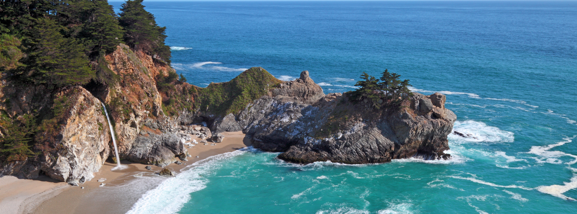
Visit McWay Falls
McWay Falls is one of the signature sights in Big Sur: a waterfall that drops into an ocean cove inside Julia Pfeiffer Burns State Park. The overlook trail is short and accessible for most visitors, which makes it one of the easiest high-reward stops on the coast.
This is one of the best places in Big Sur for travelers who want:
- a quick scenic stop
- a classic photo viewpoint
- an easy addition to a one-day itinerary
The beach below is not open for general access, so the experience is about the overlook itself rather than a beach visit.
Spend Time In Pfeiffer Big Sur State Park
If you want to balance ocean views with redwood forest, Pfeiffer Big Sur State Park is one of the most useful stops in the region. The park offers a different side of Big Sur: quieter, greener, and more grounded than the dramatic cliffside pullouts along Highway 1.
It is especially good for:
- first-time visitors who want a manageable redwood experience
- travelers combining a scenic drive with a short hike
- anyone looking for a calmer stop between major viewpoints
Visit Pfeiffer Beach
Pfeiffer Beach feels more tucked away than many Big Sur stops, and reaching it is part of the experience. The narrow access road and less obvious turnoff mean it feels separate from the main flow of Highway 1 traffic.
Travelers come for:
- the purple-toned sand
- the rock formations offshore
- the famous Keyhole Rock view
- sunset photography when conditions line up
Because access can feel less straightforward than major state park stops, it is smart to treat this as a priority stop only if you have time and conditions are favorable.
Add Point Lobos If You’re Starting From The North
Point Lobos sits just north of Big Sur proper, but it works beautifully as a north-end add-on if you are coming from Monterey or Carmel. It offers one of the easiest ways to combine wildlife viewing, shoreline trails, and dramatic coastal scenery in a relatively compact area.
If marine life and short scenic walks are part of your ideal trip, Point Lobos can pair especially well with a Big Sur day. It also complements our guide to Central Coast zoos and wildlife sanctuaries if you are building a wildlife-focused coastal itinerary.
Best Scenic Stops And Viewpoints In Big Sur
Big Sur is full of pullouts, but not every stop needs to make your itinerary. These are the kinds of places most travelers should prioritize.
Bixby Creek Bridge Viewpoint
This is the iconic opening act for many Big Sur drives. If it is your first visit, it deserves a stop.
Hurricane Point
Just south of Bixby, Hurricane Point offers broad coastal views and a strong sense of how quickly the landscape opens up once Highway 1 leaves the Carmel area behind.
McWay Falls Overlook
Short walk, high payoff, and one of the most recognizable views on the Central Coast.
Point Sur Area
Point Sur’s offshore volcanic rock formation and lighthouse setting create one of the most distinctive silhouettes on the route. Even if you are not taking a formal tour, the area is worth noticing and planning around.
Big Creek Bridge Area
Farther south, Big Creek Bridge offers another dramatic crossing with strong coastal views and a less crowded feel than the northern headline stops.
Ragged Point
Ragged Point works as a natural southern gateway to the Big Sur experience. If you are driving north, it signals that the dramatic coastline is beginning. If you are driving south, it is a satisfying final major stop before the landscape changes.
Best Hikes In Big Sur
Big Sur hiking ranges from short trails with ocean views to longer, more demanding routes through redwood canyons and wilderness terrain. Trail access and conditions can change, so it is always smart to confirm current park or forest information before setting out.
If you want broader inspiration for the region, see our guide to hiking trails on California’s Central Coast.
Ewoldsen Trail
For many travelers, this is one of the most rewarding hikes in Big Sur. It combines forest, elevation gain, and sweeping views in a way that captures the region’s strongest contrasts.
Best for:
- hikers who want one standout trail rather than several short stops
- visitors who want both redwoods and ocean views
- a half-day hiking anchor within a longer Big Sur itinerary
Partington Cove Trail
This is a shorter option with a lot of character. The route down toward the cove, combined with the coastal setting, makes it appealing for travelers who want a memorable hike without committing to a major trek.
Best for:
- short-hike travelers
- people pairing viewpoints with one worthwhile walk
- visitors interested in a more textured stop than a standard overlook
Buzzards Roost Trail
This trail offers one of the better effort-to-payoff ratios for travelers who want elevated views without a full wilderness-style outing.
Valley View / Pfeiffer Falls Area
Good for travelers who want a forest walk that feels approachable rather than strenuous. This is a sensible fit for mixed groups or itineraries where hiking is only one part of the day.
Tanbark Trail Or Longer Wilderness Routes
More ambitious hikers may want to consider longer trail options, but these require more caution, planning, and flexibility. Big Sur is not the place to improvise a difficult backcountry route without checking conditions first.
Where To Stay In Big Sur
Lodging in Big Sur is part of the appeal, but it is also one of the region’s biggest planning constraints. There are far fewer options than in Monterey, Carmel, Paso Robles, or Santa Barbara, and prices tend to reflect both scarcity and location.
Stay In Big Sur If You Want The Full Immersion
If the goal is to wake up in the landscape rather than simply drive through it, staying in Big Sur is worth it. This works best for travelers who want:
- a slower trip
- early and late access to viewpoints
- one or two hikes without a rushed turnaround
- a quieter, more removed experience
Stay In Carmel Or Monterey For Easier Logistics
If you want more restaurant choice, easier access to coffee, and a broader range of lodging, staying north of Big Sur can be the better move. Monterey especially works well if you want to combine coastal sightseeing with a more practical home base. If you are planning time there too, our guide to the best locally owned coffee shops in Monterey is a useful add-on.
Stay Farther South If Big Sur Is Part Of A Longer Highway 1 Trip
If Big Sur is one section of a longer coastal route, it can make sense to pair it with overnight stops farther south. Our guide to a weekend in Morro Bay can help if you are extending the trip down the coast, and the Cayucos shipwreck makes a worthwhile stop for travelers continuing through San Luis Obispo County.
Where To Eat, What To Pack, And Road-Trip Notes
Keep Dining Expectations Flexible
Dining in and around Big Sur is part of the experience, but this is not a destination with dense restaurant options on every corner. Hours can shift, options may be limited compared with larger towns, and some places book out or close earlier than city travelers expect.
The best approach is to:
- avoid leaving meals to chance
- pack snacks and water
- treat restaurant stops as part of your route planning, not an afterthought
Pack For Weather Shifts
Even on a beautiful day, Big Sur can move quickly between warm sun, cool wind, and fog. Bring layers, especially if your plan includes both ocean overlooks and shaded trails.
Useful basics:
- water
- snacks
- sturdy shoes
- layers
- a charged phone and backup battery
- offline maps when possible
Expect Limited Cell Service
Do not assume you will have consistent reception throughout the drive. Download directions ahead of time, screenshot reservation details if relevant, and plan with more independence than you would in an urban destination.
Best Time To Visit Big Sur
Big Sur can be compelling in every season, but the experience changes with weather, traffic, and trail conditions.
Spring
Spring often brings greener hillsides, flowing waterfalls, and strong overall scenery. It can be one of the most rewarding times to visit if you want a fresh, vivid landscape.
Summer
Summer usually brings the most visitors. The days are longer, but crowds and traffic can build quickly. It is a good time for a classic road trip, provided you plan for slower movement.
Fall
Fall can be excellent for travelers who want milder traffic and often clearer conditions. For many visitors, this is one of the most comfortable times to plan a Big Sur trip.
Winter
Winter can feel quieter and moodier, with dramatic skies and fewer visitors. It can also bring storms, closures, or changing conditions, so flexibility matters more.
A Sample 1-Day Big Sur Itinerary
If you only have one day, the goal is not to do everything. The goal is to combine a few standout stops with enough breathing room to enjoy the drive.
Morning
- start from Carmel or Monterey
- stop at Bixby Creek Bridge
- continue south through the major viewpoints
- pause at Hurricane Point or another scenic turnout
Midday
- visit McWay Falls
- add a short walk or redwood stop at Pfeiffer Big Sur State Park
- build in time for lunch and unplanned pullouts
Afternoon
- choose one additional priority stop such as Pfeiffer Beach, Point Sur area, or another viewpoint depending on your route
- continue south only as far as time and energy allow
- turn the day into a scenic loop or continue to your overnight stop
A Sample 2-Day Big Sur Itinerary
Two days is where Big Sur starts to feel less like a drive and more like a destination.
Day 1
- arrive from Monterey, Carmel, or the south
- stop at major viewpoints
- check into lodging
- do one short walk or beach stop
- enjoy sunset without feeling rushed
Day 2
- choose one substantial hike
- add one or two scenic stops you skipped the day before
- leave time for a slow breakfast, lunch, or scenic drive rather than overpacking the day
This slower structure works especially well for travelers who value atmosphere, photography, and time outdoors more than a long checklist.
Nearby Places To Add To Your Trip
Big Sur works well on its own, but it also connects naturally to other Central Coast destinations.
Monterey
Monterey is the most practical north-end pairing, especially for travelers who want a wider hotel and dining base.
Carmel
Carmel works well if you want a more polished village-style stay before or after Big Sur.
Cayucos
If you are continuing south, Cayucos adds a more relaxed beach-town stop. Our guide to the Cayucos shipwreck is especially useful if you want a memorable roadside detour.
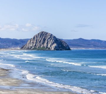
Morro Bay
Morro Bay pairs well with a longer Highway 1 route. If your road trip continues south, our guide to a Morro Bay weekend getaway can help shape the next leg.
Frequently Asked Questions About Big Sur
Is Big Sur a town?
Not in the typical sense. Big Sur is a coastal region along Highway 1 rather than a compact town with a single center.
How much time do you need for Big Sur?
A full day works for a scenic drive with several major stops. One or two nights is better if you want to add hiking, slower pacing, and time to enjoy the landscape beyond the road.
Is Big Sur worth visiting on a California road trip?
Yes, especially if scenic coastline, dramatic views, and nature are central to the trip. It is one of the defining experiences on the Central Coast.
Can you do Big Sur without hiking?
Absolutely. Many of the most rewarding stops are viewpoints, scenic pullouts, short walks, and coastal overlooks.
Where should you stay if Big Sur lodging is limited?
Monterey and Carmel are the easiest northern bases. Southbound travelers may also pair Big Sur with overnight stops farther down the coast depending on the itinerary.
Final Take
Big Sur is best approached with restraint. You do not need to stop everywhere, conquer every hike, or force a packed schedule to feel the power of the place. The strongest trips usually combine a few major viewpoints, one worthwhile walk, enough time to absorb the drive, and a realistic understanding that Big Sur is a region to experience rather than a checklist to clear.
If you plan your pace well, Big Sur delivers one of the most memorable coastal trips in California.


No comment